

Infoterra
March 18, 2009 by airianto
Filed under Geomatic Industry, Infoterra, Satellite Imagery

Terrasar
An increasing demand for precise, reliable and rapid geospatial information worldwide calls for new-quality Earth observation sensors and progressive geo-information.
Based upon the new radar satellite TerraSAR-X, Infoterra GmbH, a leading provider of geo-information products and services, offers a range of unprecedented high resolution satellite data products and reliable direct access services.

ALOS
May 3, 2008 by airianto
Filed under ALOS, Satellite Imagery

ALOS Satellite - www.jaxa.jp/projects/sat/
The Advanced Land Observing Satellite “DAICHI” (ALOS) has been developed to contribute to the fields of mapping, precise regional land coverage observation, disaster monitoring, and resource surveying. It enhances land observation technologies acquired through the development and operation of its predecessors, the Japanese Earth Resource Satellite-1 (JERS-1, or Fuyo) and the Advanced Earth Observing Satellite (ADEOS, or Midori). Read more
Adam Technology
March 19, 2008 by airianto
Filed under Adam Technology, Geomatic Industry, Photogrammetry Tools
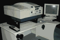
Promap Ortho System
ADAM Technology develop innovative precision measuring systems for the world of remote 3D measurement. ADAM manufacture specialist photogrammetric systems including the MPS-2 MicroPhotogrammetric Stereoplotter System, and the highly accurate, large format, PROMAP System stereoplotter, all using ADAM’s own suite of Software. ADAM is now involved in automatic 3 dimensional Dynamic Measurement technology – 3DM.
ADAM introduced the Analogue to Analytical stereoplotter conversion for the Wild B8, Kern PG-2 and the Zeiss Topocart allowing a cost-effective transition of these medium order instruments to high accuracy, PC based analytical stereoplotters. These conversions now cover the Wild BC series, and encoded solutions are available for the Wild A8 and A10 machines.


