
Drone Mavic PRO Untuk Pemetaan Fotogrametri? Bisa! – Perlu Uji Lanjut Sisi Akurasi Standar Pemetaan!
July 12, 2020 by airianto
Filed under Activities, Drone Mapping, Geomatics Business, Photogrammetry Mapping, Tutorial
Sumber: Agul Irianto’s Channel | Berlangganan:
Jajal Mavic PRO (Drone Fotografi Profesional / Amatir / Hobby) untuk pemetaan fotogrametri (photogrammetry mapping).
Ternyata bisa, dengan dibantu software capture (akuisisi) PIX4D CAPTURE lalu proses fotogrametrinya (bundle block adjustment, DSM & DTM generating, orthophoto pocessing) menggunakan software photogrammetry PIX4D MAPPER.
Read more

PCI Geomatics
October 19, 2009 by airianto
Filed under Geomatic Industry, PCI Geomatics, Photogrammetry Tools, Remote Sensing Tools

PCI Geomatics
PCI Geomatics, founded in 1982, is the world leader in geo-imaging products and solutions. PCI Geomatics has set the standard in remote sensing and image processing tools offering customized solutions to the geomatics community in over 135 countries and with more than Read more
Adam Technology
March 19, 2008 by airianto
Filed under Adam Technology, Geomatic Industry, Photogrammetry Tools
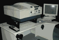
Promap Ortho System
ADAM Technology develop innovative precision measuring systems for the world of remote 3D measurement. ADAM manufacture specialist photogrammetric systems including the MPS-2 MicroPhotogrammetric Stereoplotter System, and the highly accurate, large format, PROMAP System stereoplotter, all using ADAM’s own suite of Software. ADAM is now involved in automatic 3 dimensional Dynamic Measurement technology – 3DM.
ADAM introduced the Analogue to Analytical stereoplotter conversion for the Wild B8, Kern PG-2 and the Zeiss Topocart allowing a cost-effective transition of these medium order instruments to high accuracy, PC based analytical stereoplotters. These conversions now cover the Wild BC series, and encoded solutions are available for the Wild A8 and A10 machines.
WORK EXECUTION AND WORK RESULT
January 19, 2008 by airianto
Filed under Photogrammetry, Uncategorized
In general, the implementation of the work of Airborne Laser Scanning (ALS) and aerial photomappingfor the construction of hydropower – Buttu Batu 2 x 100 MW is divided into 5 (five) stages of work: preparation, LiDAR and aerial photo data acquisition, LiDAR and aerial photo data processing, topographical map generation and quality control. The installation and measurement of the control point has not done by PT APG because it has been completed by PT Ajisaka team. PT APG uses only Read more
Geomatics
January 2, 2008 by airianto
Filed under General, Geomatics Science
Geomatics is the discipline of gathering, storing, processing, and delivery of geographic information, or spatially referenced information.
Overview
Geomatics is fairly new, the term was apparently coined by Read more