


Perlombaan Google Maps Vs Ovi Maps
March 4, 2010 by airianto
Filed under Contemporary, Geomatics Science

Ovi Maps
Siapa yang tak tergiur dengan Google Maps. Selain gratis, fasilitas ini juga dilengkapi dengan Read more

Digital Globe
November 8, 2009 by airianto
Filed under Digital Globe, Geomatic Industry, Satellite Imagery
QuickBird
DigitalGlobe was founded in 1993 under the name WorldView Imaging Corporation, became EarthWatch Incorporated in 1995, before finally becoming DigitalGlobe in 2002.
In 1993, the United States Department of Commerce Read more
GPS and Inertial Navigation
June 26, 2009 by airianto
Filed under GNSS, GPS, Geomatics Science

GPS/INS direct georeferencing
GPS aided inertial navigation systems have been available for commercial mapping applications for approximately a decade, pioneered by Canadian-based Applanix Corporation with their Read more
GPS
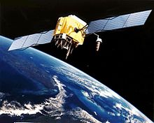
GPS Satellite
The Global Positioning System (GPS) is a space-based radio-navigation system consisting of a constellation of satellites and a network of ground stations used for monitoring and control. A minimum of 24 GPS satellites orbit the Earth at an altitude of approximately Read more
Geomatics
January 2, 2008 by airianto
Filed under General, Geomatics Science
Geomatics is the discipline of gathering, storing, processing, and delivery of geographic information, or spatially referenced information.
Overview
Geomatics is fairly new, the term was apparently coined by Read more


