


Perlombaan Google Maps Vs Ovi Maps
March 4, 2010 by airianto
Filed under Contemporary, Geomatics Science

Ovi Maps
Siapa yang tak tergiur dengan Google Maps. Selain gratis, fasilitas ini juga dilengkapi dengan Read more

GPS and Inertial Navigation
June 26, 2009 by airianto
Filed under GNSS, GPS, Geomatics Science

GPS/INS direct georeferencing
GPS aided inertial navigation systems have been available for commercial mapping applications for approximately a decade, pioneered by Canadian-based Applanix Corporation with their Read more
GPS
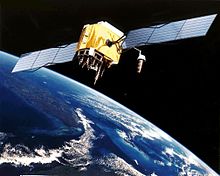
GPS Satellite
The Global Positioning System (GPS) is a space-based radio-navigation system consisting of a constellation of satellites and a network of ground stations used for monitoring and control. A minimum of 24 GPS satellites orbit the Earth at an altitude of approximately Read more
Compass Navigation Satellite
March 16, 2009 by airianto
Filed under COMPASS, GNSS, Geomatics Science

Compass Satellite
The Compass system (also known as Beidou-2, BD2) is a project by China to develop an independent global satellite navigation system. Compass is not an extension to the previously deployed Beidou-1, but a new GNSS system similar in principle to GPS and Galileo.
The new system will be a constellation of 35 satellites, which include 5 geostationary orbit (GEO) satellites and 30 medium Earth orbit (MEO) satellites, that will offer complete coverage of the globe. The ranging signals are based on the CDMA principle and have complex structure typical to Galileo or modernized GPS. Similarly to the other GNSS, there will be two levels of positioning service: open and restricted (military). The public service shall be available globally to general users. When all the currently planned GNSS systems are deployed, the users will benefit from the use of a total constellation of 75+ satellites, which will significantly improve all the aspects of positioning, especially availability of the signals in so-called “urban canyons”. The general designer of Compass navigation system is Sun Jiadong, who is also the general designer of its predecessor, Beidou navigation system.
Google Luncurkan Aplikasi Pencari Data Perusahaan

Google meluncurkan teknologi aplikasi pencari data dan informasi internal perusahaan yaitu Google Search Appliance (GSA) dan Google Mini di Indonesia.


