


GPS
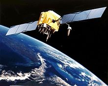
GPS Satellite
The Global Positioning System (GPS) is a space-based radio-navigation system consisting of a constellation of satellites and a network of ground stations used for monitoring and control. A minimum of 24 GPS satellites orbit the Earth at an altitude of approximately Read more

Compass Navigation Satellite
March 16, 2009 by airianto
Filed under COMPASS, GNSS, Geomatics Science

Compass Satellite
The Compass system (also known as Beidou-2, BD2) is a project by China to develop an independent global satellite navigation system. Compass is not an extension to the previously deployed Beidou-1, but a new GNSS system similar in principle to GPS and Galileo.
The new system will be a constellation of 35 satellites, which include 5 geostationary orbit (GEO) satellites and 30 medium Earth orbit (MEO) satellites, that will offer complete coverage of the globe. The ranging signals are based on the CDMA principle and have complex structure typical to Galileo or modernized GPS. Similarly to the other GNSS, there will be two levels of positioning service: open and restricted (military). The public service shall be available globally to general users. When all the currently planned GNSS systems are deployed, the users will benefit from the use of a total constellation of 75+ satellites, which will significantly improve all the aspects of positioning, especially availability of the signals in so-called “urban canyons”. The general designer of Compass navigation system is Sun Jiadong, who is also the general designer of its predecessor, Beidou navigation system.
Constellation of Galileo Satellites
April 16, 2008 by airianto
Filed under GNSS, Galileo, Geomatics Science

Galileo Constellation
When Galileo, Europe’s own global satellite navigation system, is fully operational, there will be 30 satellites in Medium Earth Orbit (MEO) at an altitude of 23 222 kilometres. Ten satellites will occupy each of three orbital planes inclined at an angle of 56° to the equator. The satellites will be spread evenly around each plane and will take about 14 hours to orbit the Earth. One satellite in each plane will be a spare; on stand-by should any operational satellite fail.
GLONASS
April 1, 2008 by airianto
Filed under GLONASS, GNSS, Geomatics Science

Glonass
The Global Navigation Satellite System (GLONASS) is based on a constellation of active satellites which continuously transmit coded signals in two frequency bands, which can be received by users anywhere on the Earth’s surface to identify their position and velocity in real time based on ranging measurements.
The system is a counterpart to the United States Global Positioning System (GPS) and both systems share the same principles in the data transmission and positioning methods. GLONASS is managed for the Russian Federation Government by the Russian Space Forces and the system is operated by the Coordination Scientific Information Center (KNITs) of the Ministry of Defense of the Russian Federation.
Galileo
March 16, 2008 by airianto
Filed under GNSS, Galileo, Geomatics Science

Galileo Satellite
Galileo will be Europe’s own global navigation satellite system, providing a highly accurate, guaranteed global positioning service under civilian control. It will be inter-operable with GPS and GLONASS, the two other global satellite navigation systems.
A user will be able to take a position with the same receiver from any of the satellites in any combination. By offering dual frequencies as standard, however, Galileo will deliver real-time positioning accuracy down to the metre range, which is unprecedented for a publicly available system. Read more


